![]()
New French Marina Entry/Exit rules
June 2025
Some of the Ports of Entry seem to have amended their processes. We travelled to Brest Chateau marina in late May and while in transit, we received the form, stamped by the douane. We needed to get our passports stamped as some of our crew were arriving/departing by ferry later in the journey, and they were happy to do that and understood the situation.
A similar process was experienced by a fellow boater in Granville. They received the following message
“We have taken into account your migration notice, and we consider that it falls under the new simplified French procedure for pleasure boaters (summer 2024).
This means that you are authorized to continue your trip as announced on the document: you can enter the pleasure port (“marina”) of Granville or Chausey, or leave depending on the type of notice (Arrival or Departure), without systematic physical check and without stamping your passport (you can continue your journey without having to go to the Granville migration control office).
If we ultimately wish to meet you, we will meet you at the marina using the times declared on your documents.
If you wish to meet with us, or if the information you have communicated to us has changed (date or time, names or number of passengers, etc.), let us know as soon as possible.”
30th May 2024
We are delighted to announce the new arrangements now in place. Please see the following Official Press release
Communiqué press_english version
Thank you to the French authorities as well as the ports and marina officials who worked so hard to introduce these new rules.
The PPF they refer to are the official Ports of Entry. The new rules are for non-PF marinas. In the past, you had to go to a PPF marina first (with a few exceptions) and now that has all changed for the better.
This is the form that needs to be completed. I am not sure it is the final version of the form but is the one that Treguier kindly provided. I suggest you contact the marina you will be visiting for their version of the form.
Word version (.docx file) Annexe-1-Formulaire-declaratif
Word version (open .odt file) Annexe 1 – Formulaire déclaratif
PDF version (may not be editable for some users) Annexe-1-Formulaire-declaratif
PDF version (I had done some work to turn it into a form, not sure how well it will work) Annexe-1-Formulaire-declaratif editable
The new arrangements will no doubt raise some questions and I have started a Question and Answers section below
Please email marinas@digimap.gg with any updates that would be useful to fellow boaters, including photos.
25th June 2024 update
-
If a boat arrives in France via a non-PPF port (see Annexe 2 below) it should only leave by another non-PPF port. No inspection of passports is required, as all information concerning persons on board is contained in the Declarations of Arrival and Departure submitted to the marina authorities for onward transmission to the Border Authorities.
-
If a boat arrives and leaves by the same non-PPF port, no inspection of passports is required for the same reasons as given in 1)
-
If a boat arrives in France via a PPF port (see Annexe 3) it must leave via a PPF port, and passports will be stamped on arrival and departure by the Border Authorities, although Declarations of Arrival and Departure must still be submitted to the relevant marina authorities.
Question: Which are the marinas under this new arrangement?
Answer: This is the list of the marinas – Annexe 2 – Liste ports de plaisance éligibles rev
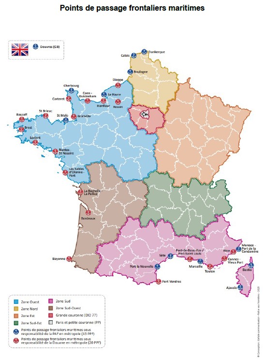
PPF Ports of Enrtry
Question: How does this affect the existing official Ports of Entry?
Answer: It would appear for all marinas you need to send in your form in advance
If the marina has a customs office, for example, Roscoff, Le Légué (Saint Brieuc), Saint Malo, they will stamp your passport
If the marina does not have a customs office – for which these new rules apply. They will make your stamped form available for you at the marina or send it to you. Please do remember to retain your stamped form.
Question: What about Carteret and Dielette?
Answer: We are informed Carteret is planning to adopt a similar arrangement to Dielette and Brittany, hopefully, this will be resolved in the next couple of weeks. Dielette remains unchanged, just send the form to Dielette as per normal. You no longer need to send it to the Douane.
Some further information and clarifications: www.noonsite.com/news/france-more-on-new…
See also www.eskaledarmor.com/en/brexit-procedure…
Northern Brittany has been very pro-active and most are covered by the Eskale d’Amour group of marinas.

As a boating enthusiast living in Guernsey, I have been collecting important information and websites of marinas to visit from the Channel Islands and the UK. This is a portal, a collection of links to pages for each marina which I hope will save you time and enhance your trip.
Blogs
The blogs are available using the following links
- Blog for the Trip to Southern Brittany
- Blog for the Trip to Normandy 2018
- Blog for the Trip to Rade de Brest 2019
Motor Boat and Yachting Articles
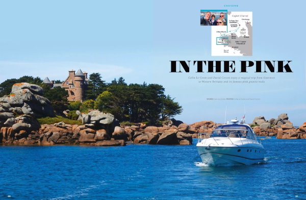
We were pleased to support Motor Boat and Yachting with the recent articles about our trip to Western Brittany and bays around the Channel Islands.
Brittany boating guide: Princess owners explore France’s rugged west coast
Channel Islands boating: Local’s guide to Guernsey and its stunning neighbours
YouTube and Mapping sites
Do visit my YouTube Channel, which provides you with a “boat eye” view of what you can expect to see when arriving at the marinas. Very useful for your first visit – www.youtube.com/channel/UCrLqAsXKGHqxQRj…
I have set up a Facebook open group for boaters who visit Brittany, Normandy and Channel Island Marinas. We will post to this site with the latest updates. www.facebook.com/groups/2397448260334302
There is a new website – ports-manche.com/ . If you have Chrome or Edge (use the new chromium-based edge – it is a lot better than the old one). Download the Google Translate plugin and it will translate any French pages for you.
Digimap is providing this site free of charge to help the boating community. We hope the links will be useful. Any additional information and photos would be much appreciated. If anyone could write a paragraph or two on your favourite marina – please send it to info@digimap.gg. We can keep these pages really up to date with the latest information.
Please call the marinas direct if you wish to find out how busy they are. Nearly all the Brittany and Normandy marinas DO NOT take reservations and so beware of 3rd party sites offering bookings.
SNSM – Lifeboat
The lifeboat does not work the same in France as the RNLI in the UK. Some are moored inside of marinas, so do ensure you only require them from half tide up! Also, they often make a charge. A French skipper was towed in, in June 2024 and running a towing service cost him Euro 300 (per hour, maybe, and that was by a large SNSM rib, not offshore lifeboat). It is suggested there would be no charge for saving lives at sea.
Still a great service if you have a problem!
If anyone has any further information/clarification, please let me know at marinas@digimap.gg