![]()
This site has been developed by digimap with the hope that it will assist with the enjoyment of your boating.
Guernsey Tides
The calculates the times you should be able to pass over the sill of the respective marina. It is calculated based on the tidal predictions, but can vary due to barometric pressure, wind direction and strength and many other factors. Additionally, gates may be affected by the speed of the flow of water over the gate.
The predictions are less accurate during neap tides when the height of the tide changes slowly.
The system does take into account the dropping gates at QEII and St Sampsons marinas.
At the bottom of the page is the Tide Height above Chart Datum each half-hour.
Marina Times
This allows you to select a marina and then select a date range and will show you the times for each day. This was a much requested feature, especially if you are planning to be away for a few days. Please do check you have the correct marina selected. It should remember your chosen marina on your device.
We do hope you enjoy the site and will think of digimap for all your mapping requirements.
Anchoring
This is a new feature. You go to Herm and moor your boat at shell beach. This raises a number of questions.
- How much chain should I put out to be OK at high tide based on the 4x depth guideline?
- Will I dry out?
- If I take my dinghy ashore, when will the tide be back at this level so it does not float away?
This page provides the answers.
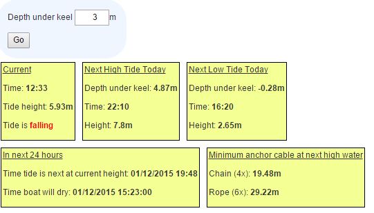
In the screenshot above, the tide is falling and we have entered a depth of 3 metres under the keel. This is not the figure on your depth sounder so beware. If your depth sounder says the water is 4m deep and you draw 1m then there is 3m under the keel.
The time and depth at the next high tide is calculated and this calculates the anchor chain and rope required if you are going to stay until the next high tide. You may wish to increase the length in strong tides and / or rough conditions.
The next box shows the depth under the keel at low tide. In this example, the boat will go aground and the next box shows this will happen at 15:23. The time the tide will be back at the same height will be 19:48, so your dinghy on the beach should be safe until then.
Do have a play, test the results and let me know of any feedback.
Barometric Pressure
Tide predictions are computed for a standard barometric pressure of 1013 millibars. A difference from the average of 1 millibar can cause a difference in height of 1 centimetre. A low barometer will allow the sea level to rise and a high barometer will tend to depress it. The water level does not, however, adjust itself immediately to a change of pressure; it responds to the average change over a considerable area. Changes in sea level due to barometric pressure alone seldom exceed 30 centimetres but since the air pressure can vary between 950 and 1050 millibars during a year, the variation in sea level due to air pressure could be as much as between +63 cm and -37 cm around mean sea level. As such circumstances are usually associated with adverse weather conditions, the actual change in sea level can be greater.
For information on the Channel Island tides – see www.astronomy.org.gg/more/resources/educ…